The Record · Chapter One · About 1300 to 1763
The Carry
Before there was a Chicago there was a six-mile walk through wet prairie. Whoever held it priced everything that crossed it. The fight over that walk is older than any flag.
Chicago · 30 September 2026 · Revised 1 October 2026
A village on a bluff
Start about the year 1300, on a bluff above the Illinois River in what is now Fulton County, a short drive from Dickson Mounds. Archaeologists call the place Norris Farms. The people who lived there farmed corn, fished the river and buried their dead in one cemetery on the edge of town.
When that cemetery was studied, the bones told a hard story. At least a third of the adults died by violence. Arrow wounds. Blows to the head. Scalping marks. Some were buried with the wounds that killed them still plain to see.
We start there on purpose. The ground this city sits on was fought over long before anybody sailed in from Europe. People have always fought over good ground and the roads across it. It is the table everything later was served on.
The walk
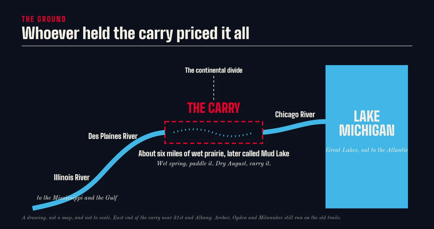
Water from the Great Lakes runs east to the Atlantic. Water from the Des Plaines runs south to the Mississippi and the Gulf. On the southwest side of what is now Chicago, those two worlds come within about six miles of each other, with a low, soggy stretch of prairie in between. People later called it Mud Lake. Its east end sat near what is now 31st and Albany.
In a wet spring you could paddle most of it. In a dry August you picked up your canoe and your cargo and carried it. That is the portage. The carry.
Whoever held the carry could price everything that crossed it. Furs going east. Trade goods going west. News going both ways. The trails that fed it are still under your tires. Archer, Ogden and Milwaukee avenues cut on a slant across a city laid out in squares because they were trails before they were streets.
The nations
The people on this ground were many, and they were separate. Potawatomi. Ojibwe. Odawa. Myaamia, the Miami. The Inoka, the Illinois, who were themselves several peoples, the Peoria, Kaskaskia, Cahokia, Tamaroa and Michigamea. Ho-Chunk. Menominee. Sauk. Meskwaki, whom the French called the Fox. Kickapoo. Mascouten. Wea. Piankashaw.
Separate governments. Separate interests. Separate alliances that shifted with the seasons and the wars. They did not all get along, and some of them fought each other hard.
The city’s own name comes from them. Shikaakwa, a Miami-Illinois word for a wild onion that grew along the river.
These nations are not a chapter that closes. Their people are still here, in this city and across the country, and some of their governments are still dealing with the paper that follows in this Record. They are the spine of it. Everything else hangs off them.
Fort Orange, a thousand miles east
The first hand in this game was dealt from somewhere else.
In 1624 the Dutch set up Fort Orange on the Hudson River, where Albany sits today. It was a trading post, and what it wanted was beaver. Europe had a craze for felt hats, and the best felt came from beaver fur. The Dutch paid in cloth, kettles, knives and guns.
The guns mattered most. The Haudenosaunee, the five nations Europeans called the Iroquois, traded at Fort Orange and armed up. Then they pushed west for more beaver and more ground. Historians call what followed the Beaver Wars. They ran on and off from about 1609 to the Great Peace of 1701.
Out here the damage was enormous. Whole nations were scattered, swallowed up or driven off. By the late 1600s the Illinois had been pushed south out of their own villages.
A hat fashion in Europe paid for a Dutch trading post in New York, which armed one set of nations, who drove other nations off the ground that became Chicago. The Dutch never had to come west to do it.
That is the first lever on this ground. Goods and guns. Nobody who pulled it had to be in the room where it landed.
Fort Orange has its own chapter, The Beaver and the Gun.
Jolliet's pitch
In September 1673 two Frenchmen came through. Louis Jolliet was a fur trader. Jacques Marquette was a Jesuit priest. Native people who already used the carry showed it to them.
Jolliet went home and reported to the French government. His big idea was to cut a canal through the carry, so a boat could float from the lakes to the Gulf without anybody picking it up.
So the first official European act on this ground was not a flag or a prayer. It was a construction pitch. It would take 175 years for somebody to dig it.
The fort and the gatekeeper
The French came back with forts. In 1680 René-Robert Cavelier, Sieur de La Salle, built Fort Crèvecoeur on the Illinois River near the Peoria village. It was the first French fortification in the Illinois country.
A fort did more than hold ground. It told everybody who the gatekeeper was. Who got to trade. Who got the guns and the powder. Who got the gifts that kept a chief friendly. The French handed out presents to leaders they wanted on their side, and they married into families that could open doors. Traders took Native wives, and their children grew up speaking both languages and holding both sets of keys.
Four levers, all at once. The fort. The gatekeeper. Gifts and payments to leaders. Marriage and family. All of it was out in the open, the ordinary way of doing business.
The Meskwaki wars
The old souvenir books skip what came next.
The Meskwaki held another carry, the Fox-Wisconsin portage to the north. They charged tolls on it, and they refused to let French guns pass through to their enemies. That was their leverage, and they used it.
The French answer was war. In 1712 a Meskwaki siege of the French post at Detroit failed, and French-allied forces killed many. By French colonial accounts, roughly 100 men died and some 900 women and children were taken prisoner. Those same accounts mention a trade in captives through the Illinois country. We have not traced that trade yet. It is a hole, and we name it below.
In August 1730 a Meskwaki group was cornered on the prairie near present-day Arrowsmith, Illinois, east of Bloomington. The French and their allies built a fort around them and cut off their water and food. The siege ran 23 days. When the Meskwaki tried to slip out at night, their children’s crying gave them away. About 50 fighting men got away. Most of the women and children who lived were taken as slaves.
Under the uniforms, the story is plain. A people who controlled a toll road refused to let a competitor’s guns through. The competitor settled the dispute by trying to wipe them out.
We call it force as the collection department. It was run on the Illinois in 1680, and it will come back in 1838, 1877, 1886, 1894 and after.
Who scored
By 1763 the French were done. They lost the war with Britain, and in the Treaty of Paris they signed their claims in this country over to London. The ground did not change hands between the people living on it. It changed hands on paper, between two kings who had never seen it.
The next chapter begins with paper.
The scoreboard
Who got paid
- The Dutch traders at Fort Orange. Beaver, bought with goods and guns, without ever coming west
- French trading houses and the officers who ran the forts. Furs, and the gatekeeper’s cut on every trade
- Europe’s hat makers. The felt
Who pays
- The Illinois. Pushed south out of their own villages by armed neighbors
- The Meskwaki. A toll road, and most of a people, for refusing to let French guns pass
- Every nation on this ground. Their standing at the table, traded away in 1763 by two crowns
Holes, named
What we do not have yet
- The captive trade through the Illinois country, named in passing in the 1712 accounts. Not yet traced.
- The years between the Beaver Wars and 1763 for the Potawatomi, Miami and Illinois, told from their own records and oral history where they have chosen to share them.
Sources
The record
- George R. Milner, Eve Anderson and Virginia G. Smith, “Warfare in Late Prehistoric West-Central Illinois,” American Antiquity, 1991, and Milner and Smith, Human Skeletal Biology and Norris Farms #36. The Jolliet and Marquette voyage of 1673 and Father Claude Dablon’s 1674 account of Jolliet’s report to Governor Frontenac. French colonial accounts of the 1712 siege at Detroit and the 1730 siege near Arrowsmith. The Treaty of Paris, 1763. Treaty and nation histories held by the Citizen Potawatomi Nation Cultural Heritage Center and the Prairie Band Potawatomi Nation.
Read next
Fort Orange, The Beaver and the Gun1621 to 1701
Chapter Two, The Ditch and the Deed1763 to 1849
The Record, all chaptersThe preface, the chapters and the corrections.