The Record · Chapter Two · 1763 to 1849
The Ditch and the Deed
How a president’s private letter, a killed public store, a map drawn to sell lots and a treaty signed six weeks after the town turned the carry into Chicago.
Chicago · 30 September 2026
Paper from far away
In 1763 France signed its claims here over to Britain. Twenty years later, in 1783, Britain signed them over to the new United States. Neither handoff asked the people living on the ground.
The British years here, 1763 to 1783 and the loose years after, are mostly empty in our files. We know about Pontiac’s War in 1763, when nations across the Great Lakes rose against British posts, and about the royal line that year meant to keep settlers east of the mountains.
The man at the river mouth
Before any fort, Jean Baptiste Point du Sable was trading at the mouth of the Chicago River. He was a Black man, likely born in the Caribbean, married to a Potawatomi woman named Kitihawa. He ran a farm and a trading house there in the 1780s and 1790s.
In 1800 he sold out and left. Who bought, for how much, and whether he got a fair shake are questions we are still digging on. We will not write that story until we have the sale papers in hand. What we will say now is that he was here first among the newcomers, and the city took a long time to admit it.
The first bite
On August 3, 1795, at the Treaty of Greenville, the nations of the Ohio country signed away much of what is now Ohio after losing a war. Tucked into that treaty was a small item. A six-mile square at the mouth of the Chicago River.
That was the United States’ first official bite of Chicago. Fort Dearborn would sit on that square. So the fort was not built on empty earth. It was built on a deed.
The public store
From 1795 the federal government ran trading houses called factories. They sold goods to the nations at cost. No markup. It was, in plain words, a public option. It kept private traders from gouging and it kept the nations from sinking into debt.
Keep that store in mind. It is about to be killed, and who killed it matters.
The letter
On February 27, 1803, President Thomas Jefferson wrote to William Henry Harrison, governor of the Indiana Territory. He marked the letter private and unofficial. He said so because the official channel was the public record.
In it Jefferson laid out the method. Push the trading houses. Be glad to see the influential men among the nations run into debt, because once the debt passed what they could pay, they would be willing to settle it by giving up land.
There it is, in a president’s own hand, the same year the fort went up. We call it the debt lever. Extend the credit. Let it grow past what can be paid. Collect in land. It runs from this letter all the way to the contract sellers of the 1950s and the bankers of this decade.
Fort Dearborn
In 1803 United States troops under Captain John Whistler built Fort Dearborn on the six-mile square.
In 1812 the country went to war with Britain, and many nations of the Great Lakes sided with the British, who looked like the better bet for keeping the Americans off their land. After the British took the fort at Mackinac, General William Hull ordered Fort Dearborn evacuated.
On the morning of August 15, 1812, the garrison marched out. By the commander’s own report there were 54 regular soldiers, 12 militiamen, 9 women and 18 children. About 400 to 500 Potawatomi warriors attacked them along the lakeshore. Captain Nathan Heald reported 26 regulars, all 12 militiamen, 2 women and 12 children killed. The fort was burned.
The city put that day on its flag as a star. For a long time it was told as a massacre and nothing else. It was a battle in a war, fought by nations defending ground that was being taken one square at a time. A star does not have room for both. This Record does. The fort was rebuilt in 1816.
Killing the store
The same year the fort came back, the United States took the portage itself. The 1816 treaty ceded a strip of land along the carry.
Then came the store. On May 6, 1822, President James Monroe signed the bill that abolished the factory system. John Jacob Astor’s American Fur Company had lobbied for it. The senator who led the fight, Thomas Hart Benton of Missouri, was at the same time on Astor’s payroll as his legal man. Lewis Cass, governor of the Michigan Territory, helped.
With the public store gone, private traders ran the credit. And private traders were the ones who would later stand in the treaty camp with their bills.
Astor, for his part, took his fur money to Manhattan and bought land. He became the richest landlord in New York. That is the first time money from this ground left for a New York room. It will not be the last.
We call this play kill the public option. Shut down whatever the public runs at cost. Then charge for it.
The map drawn to sell
Congress and Illinois now wanted the canal Jolliet had pitched. They paid for it with land instead of money.
In 1822 Congress granted a strip for a canal. In 1827 it granted Illinois about 284,000 acres in alternate sections, a checkerboard five miles deep on each side of the planned route. The state would sell its squares to pay for the digging. The squares the United States kept would rise in value because the ditch was coming.
There was a problem. Nobody wanted the land. It would not sell at $1.25 an acre. So in 1829 the new canal commission decided to invent towns to make it sell.
On August 4, 1830, surveyor James Thompson finished the first plat of Chicago. Blocks, lots, streets. It was drawn to sell lots to pay for a canal.
Chicago was not founded. It was issued.
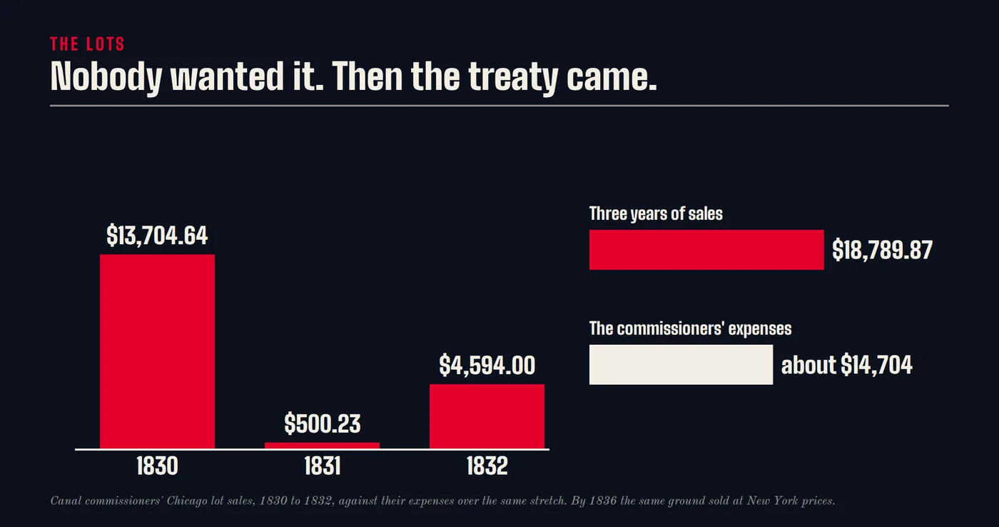
And the lots did not sell. The commissioners took in $13,704.64 in 1830, $500.23 in 1831 and $4,594.00 in 1832. That is $18,798.87 in three years. Their own expenses over the same stretch came to about $14,704. Three years of selling Chicago barely paid the men doing the selling.
The town before the treaty
Meanwhile the nations kept signing. Treaties in 1821, 1829 and 1832 took more ground. The 1829 Treaty of Prairie du Chien set aside a reservation for a Potawatomi leader named Shab-eh-nay and his people in what is now DeKalb County. Remember that one.
In 1832 the Sauk leader Black Hawk led a band of his people back across the Mississippi into Illinois. The Army and the militia chased them for months. It ended that August at the Bad Axe River in Wisconsin, where soldiers shot people trying to cross the water. The war also put a scare into every settler in the state, and the scare was useful to anyone who wanted the nations gone.
On August 12, 1833, about 350 people organized the Town of Chicago. Trustees, a charter, the works.
Six weeks later, on September 26, 1833, the Treaty of Chicago was signed. The Ojibwe, Odawa and Potawatomi gave up on the order of five million acres in Illinois and the Michigan Territory. The government’s side of the table was George B. Porter, Thomas J. V. Owen and William Weatherford. Payment came as yearly annuities, presents, a tract of land west of the Mississippi, and debts wiped off a trader’s book.
Those debts are the debt lever coming due, thirty years after Jefferson’s letter. The treaty scheduled $175,000 in claims from traders and creditors. It budgeted $150,000 to pay the claims the nations actually admitted to. The gap is why the United States Senate looked at that pile and called it inflated.
The treaty also ran two clocks. The Illinois land was due as soon as the treaty was ratified. The land north of the state line got three years. The fast clock covered the ground this city sits on.
So the town came first and the paperwork caught up. The ground that could not fetch $1.25 an acre in 1831 was selling at New York prices by 1836.
The land was never worthless. It was occupied.
The boom and the bust
In 1835 the legislature authorized a $500,000 loan for the canal. Bonds went out in 1836. The cost estimate jumped to $8,654,000. The first spade went in on July 4, 1836.
On March 4, 1837, Chicago got its city charter. The first mayor was William B. Ogden, who with his brother owned land at the portage. When the man running the city owns the ground the city is spending money to improve, you do not need a secret meeting. We call that play the seating chart.
Then the Panic of 1837 hit. The land market collapsed. The state that had bet its credit on selling lots nearly went under, and its paper ended up in London. The buyers at the 1836 top were wiped out. The ones who could wait ended up owning the hinge between two watersheds.
The Trail of Death
The treaty’s clocks ran out. On September 4, 1838, about 859 Potawatomi were marched out of Twin Lakes, Indiana, under militia guard, headed for Kansas. Their leader Menominee had refused to sign. He said, through an interpreter, “I have not sold my lands.”
The march covered about 660 miles in 61 days. More than 40 people died on the road, 28 of them children. A young Catholic priest named Benjamin Petit went with them and tended the sick. He died on his way home the next February, at 27.
This is not the Trail of Tears. That was the Cherokee. This is ours, and it has its own name.
The ditch
The canal took twelve years of digging, 96 miles by hand, much of it by Irish immigrants in a corridor where cholera came through. We do not yet have the canal commission’s payroll records, so we will not print a number for how many dug it, what they were paid or how many died. That is a hole we intend to fill.
In April 1848 the Illinois and Michigan Canal opened. Jolliet’s pitch, 175 years late. That same year the Chicago Board of Trade was founded. Within a decade Chicago was the hinge of American commerce.
Shab-eh-nay's land
Remember the reservation from 1829. In 1849, while Shab-eh-nay was in Kansas visiting family, the federal government auctioned off more than 1,280 acres of his treaty-guaranteed land. It was illegal. Every treaty in this chapter was broken somewhere. This is the one with the cleanest paper trail.
A door, not a wall
On April 19, 2024, the Interior Department placed 130 acres of the Shab-eh-nay Reservation into trust for the Prairie Band Potawatomi Nation. It is the only federally recognized tribal land in Illinois, and it made Illinois the 35th state with a reservation. It came 175 years after the illegal auction. The Nation’s chairman, Joseph “Zeke” Rupnick, is Shab-eh-nay’s fourth-great-grandson.
In March 2025 Governor Pritzker signed the transfer of about 1,500 acres of Shabbona Lake State Park in DeKalb County to the Nation for one dollar, with an agreement to keep it open to the public.
Wins add up. That is one.
The scoreboard
Who got paid
- John Jacob Astor. The fur trade without a public store, then Manhattan land
- Traders and creditors in the 1833 treaty camp. Up to $175,000 in claims, paid out of the nations’ own sale
- Canal commissioners and early lot buyers who could wait out 1837. The junction of two watersheds
- William B. Ogden. Land at the portage, and the mayor’s chair
Who pays
- The Ojibwe, Odawa and Potawatomi. About five million acres, for annuities, presents and wiped-off debts
- The Potawatomi of Twin Lakes. Their homes, and more than 40 lives on the road to Kansas
- Shab-eh-nay and his people. 1,280 acres, auctioned while he was away
- The canal diggers. Wages and lives we cannot yet count
Holes, named
What we do not have yet
- The British years, 1763 to 1795, and what London’s traders did on this ground.
- Jean Baptiste Point du Sable’s 1800 sale. The buyer, the terms and the inventory.
- The canal payroll. How many dug it, what they were paid, whether in cash or scrip, and how many died.
- The Black Hawk War told from Sauk and Meskwaki records.
Sources
The record
- Treaty of Greenville, 3 August 1795. Thomas Jefferson to William Henry Harrison, 27 February 1803. Captain Nathan Heald’s report on the evacuation of Fort Dearborn, 1812. Treaty of St. Louis, 1816. Act abolishing the Indian trading house system, 6 May 1822. Canal land grants of 1822 and 1827. James Thompson’s plat of Chicago, 4 August 1830, and the canal commissioners’ sales accounts, 1830 to 1832. Treaty of Prairie du Chien, 1829. Treaty of Chicago, 26 September 1833, and its schedule of claims. Chicago city charter, 4 March 1837. Illinois canal loan acts of 1835 and 1836. Accounts of the 1838 removal from Twin Lakes, including Father Benjamin Petit’s letters and the Citizen Potawatomi Nation’s history of the Trail of Death. United States Department of the Interior, trust decision for the Shab-eh-nay Reservation, 19 April 2024. State of Illinois, Shabbona Lake State Park transfer, March 2025.
Read next
Chapter One, The CarryAbout 1300 to 1763
Chapter Three, The Franchise and the Fire1848 to 1893
The Record, all chaptersThe preface, the chapters and the corrections.